
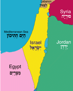
Location
Israel is located in the Middle East, along the eastern coastline of the Mediterranean Sea, bordered by Lebanon, Syria, Jordan and Egypt. It lies at the junction of three continents: Europe, Asia and Africa.
Geography
Long and narrow in shape, the country is about 290 miles (470 km.) in length and 85 miles (135 km.) in width at its widest point. It covers an area of about 21,596 sq km (about 8338 sq mi).
Although small in size, Israel encompasses the varied topographical features of an entire continent, ranging from forested highlands and fertile green valleys to mountainous deserts and from the coastal plain to the semitropical Jordan Valley and the Dead Sea, the lowest point on earth. Approximately half of the country’s land area is semi-arid.
Elevation
Lowest Point: Dead Sea (408 Meters below sea level)
Highest Point: Har Meron (1,208 Meters above sea level)
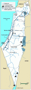
Water
The scarcity of water in the region has generated intense efforts to maximize use of the available supply and to seek new resources. In the 1960s, Israel’s freshwater sources were joined in an integrated grid whose main artery, the National Water Carrier, brings water from the north and center to the semi-arid south. Ongoing projects for utilizing new sources include cloud seeding, recycling of sewage water and the desalination of seawater.